Live Image Grid (Click to View)


Tropical
Imagery Tropical
Imagery 2

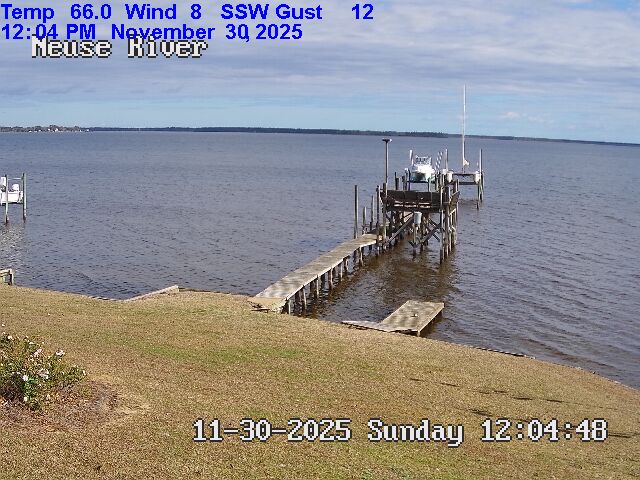
Viewing mouth of Upper Broad Creek, just below Northwest Creek and
Fairfield Harbour, taken South of Johnson Point facing ENE
Expires:202607290000;;223188
FZUS52 KMHX 281502
SRFMHX

Surf Zone Forecast
National Weather Service Newport/Morehead City NC
1102 AM EDT Tue Jul 28 2026


NCZ195-290000-
West Carteret-
Including the beaches of Fort Macon, Atlantic Beach,
Pine Knoll Shores, Salter Path, and Emerald Isle
1102 AM EDT Tue Jul 28 2026

.REST OF TODAY...
Rip Current Risk*...........Low.
Surf Height.................1 to 3 feet.
Thunderstorm Potential**....None.
UV Index**..................Moderate.
Water Temperature...........In the mid 80s.
Weather.....................Partly sunny.
High Temperature............In the upper 80s.
Winds.......................Southwest winds 10 to 15 mph.
Tides...
   Atlantic Beach...........Low 0.2 feet (MLLW) 01:04 PM EDT.

.WEDNESDAY...
Rip Current Risk*...........Moderate.
Surf Height.................3 to 4 feet.
Thunderstorm Potential**....None.
Weather.....................Sunny.
High Temperature............In the upper 80s.
Winds.......................West winds around 10 mph.
Tides...
   Atlantic Beach...........High 3.2 feet (MLLW) 07:40 AM EDT.
                            Low 0.2 feet (MLLW) 01:46 PM EDT.

&&

Rip Current Risk Category
* Low Risk - The risk for rip currents is low, however,
life-threatening rip currents often occur in the vicinity of groins,
jetties, reefs, and piers.
* Moderate Risk - Life-threatening rip currents are possible in the
surf zone.
* High Risk - Life-threatening rip currents are likely in the surf
zone.

** For thunderstorm, waterspout, and UV definitions see:
https://www.weather.gov/beach/mhx

$$
Any
suggestions or requests please email
me by this link.
Last Updated 12:41pm on 7/28/26
2
Days Ahead 4
Days Ahead All
6 Days Beach
Since the sensor is on the water then the temperature, humidity and
winds can be quite different from the airport less than 5 miles away. All
info. is recorded from a Rainwise
MKIII mounted 20 feet
above sea level using Ambient Virtual Weather Station software.
Located on the Lower Neuse River across from Northwest Creek, Upper Broad and
Fairfield Harbour.
|
|
|
|||||||||||||||||||||

![]()


Updated at 6am
Today's Forecast for 2pm (updated at 6am)
Tomorrow at 2pm (updated at 6am)
2 Days From Now at 2pm (updated at 6am)
3 Days From Now at 2pm (updated at 6am)
4 Days From Now at 2pm (updated at 6am)
5 Days From Now at 2pm (updated at 6am)
6 Days From Now at 2pm (updated at 6am)
7 Days From Now

9 Days From Now
12 Days From Now
Updated at 6pm
2pm (updated at 6pm)
2 Days From Now at 2pm (updated at 6pm)
3 Days From Now at 2pm (updated at 6pm)
4 Days From Now at 2pm (updated at 6pm)
5 Days From Now at 2pm (updated at 6pm)
6 Days From Now at 2pm (updated at 6pm)
7 Days From Now
9 Days From Now
12 Days From Now
New Bern Area Weather Forecast
|
|
|
|
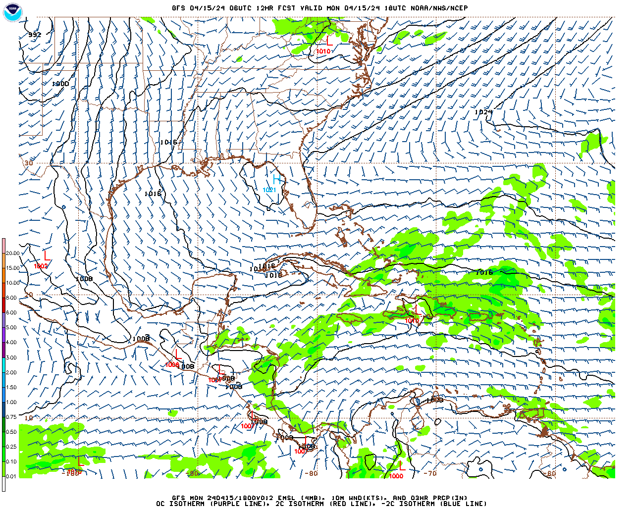
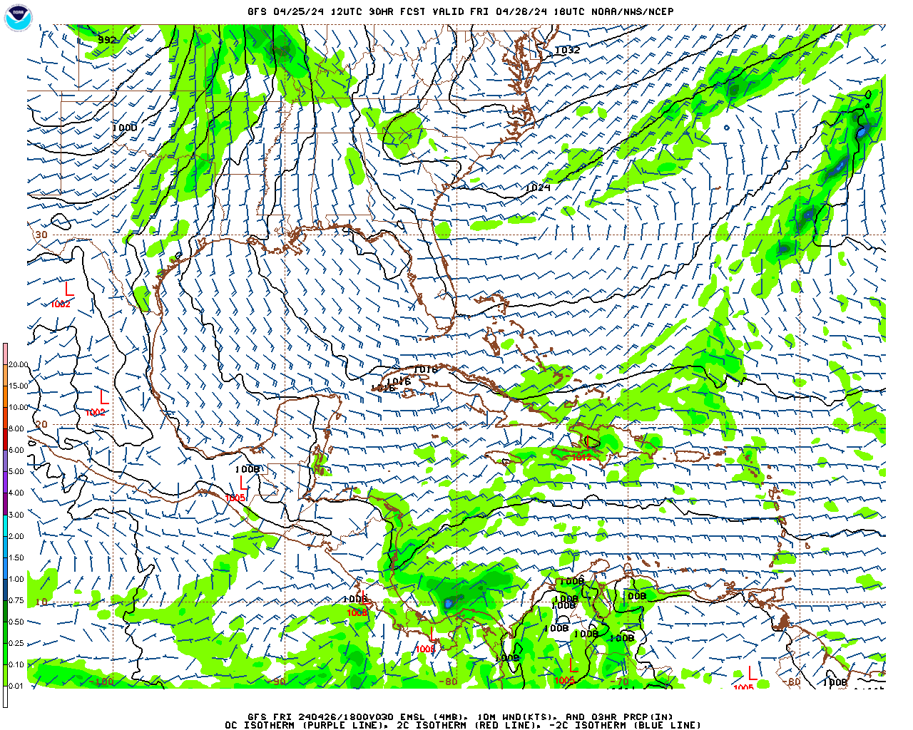
Weather Synopsis
Expires:202607282330;;214207 FZUS52 KMHX 281021 CWFMHX Coastal Waters Forecast for North Carolina National Weather Service Newport/Morehead City NC 621 AM EDT Tue Jul 28 2026 From S of Currituck Beach Light to N of Surf City NC out 60 NM, including the Albemarle and Pamlico Sounds and the Monitor National Marine Sanctuary AMZ100-282330- 621 AM EDT Tue Jul 28 2026 .Synopsis for Eastern North Carolina coastal waters... A strong cold front and low pressure will approach the area today, pushing through tonight. Gusty SSW winds will develop late this afternoon, peaking tonight. Scattered strong to severe thunderstorms will be possible. High pressure moves back in mid- week with a reduced risk of thunderstorms. $$ |
Neuse and Bay River Marine Forecast
Expires:202607282330;;214213 FZUS52 KMHX 281021 CWFMHX Coastal Waters Forecast for North Carolina National Weather Service Newport/Morehead City NC 621 AM EDT Tue Jul 28 2026 From S of Currituck Beach Light to N of Surf City NC out 60 NM, including the Albemarle and Pamlico Sounds and the Monitor National Marine Sanctuary AMZ137-282330- Neuse and Bay Rivers- 621 AM EDT Tue Jul 28 2026 .TODAY...SW winds 5 to 10 kt, increasing to around 15 kt late. Waves light chop, increasing to a moderate chop late. .TONIGHT...SW winds 10 to 15 kt. Waves a moderate chop. Showers and tstms. .WED...NW winds 5 to 10 kt. Waves light chop. .WED NIGHT...W winds 5 to 10 kt. Waves light chop. .THU...NW winds 5 to 10 kt. Waves light chop. .THU NIGHT...NW winds around 5 kt. Waves flat. .FRI...NW winds around 5 kt, becoming S in the afternoon. Waves flat. .FRI NIGHT...S winds around 5 kt. Waves flat. .SAT...S winds around 5 kt, becoming SE in the afternoon. Waves flat, increasing to light chop in the afternoon. .SAT NIGHT...SE winds 5 to 10 kt. Waves light chop. Winds and waves higher in and near tstms. $$ |
Pamlico Sound Marine Forecast
Expires:202607282330;;214211 FZUS52 KMHX 281021 CWFMHX Coastal Waters Forecast for North Carolina National Weather Service Newport/Morehead City NC 621 AM EDT Tue Jul 28 2026 From S of Currituck Beach Light to N of Surf City NC out 60 NM, including the Albemarle and Pamlico Sounds and the Monitor National Marine Sanctuary AMZ135-282330- Pamlico Sound- 621 AM EDT Tue Jul 28 2026 ...SMALL CRAFT ADVISORY IN EFFECT FROM 6 PM EDT THIS EVENING THROUGH LATE TONIGHT... .TODAY...SE winds 5 to 10 kt, becoming S 15 to 20 kt. Waves 1 to 2 ft, then 2 to 3 ft this afternoon. .TONIGHT...SW winds 15 to 20 kt with gusts up to 25 kt. Waves 2 to 3 ft. Showers and tstms. .WED...NW winds 10 to 15 kt, becoming W 5 to 10 kt in the afternoon. Waves around 2 ft in the morning, then 1 ft. .WED NIGHT...W winds 5 to 10 kt. Waves 1 ft or less. .THU...NW winds 5 to 10 kt. Waves 1 ft or less. .THU NIGHT...N winds around 5 kt, becoming W after midnight. Waves 1 ft or less. .FRI...NW winds around 5 kt, becoming SW in the afternoon. Waves 1 ft or less. .FRI NIGHT...S winds around 5 kt. Waves 1 ft or less. .SAT...S winds 5 to 10 kt. Waves 1 ft or less. .SAT NIGHT...S winds 5 to 10 kt. Waves 1 ft or less. Winds and waves higher in and near tstms. $$ |
Atlantic Beach Forecast
Expires:202309170800;;465863 FPUS52 KMHX 111924 ZFPMHX Zone Forecast Product for Eastern North Carolina National Weather Service Newport/Morehead City NC 1248 AM EDT Fri Aug 17 2018 NCZ095-170800- Carteret- Including the cities of Morehead City, Beaufort, Newport, Atlantic Beach, and Emerald Isle 1248 AM EDT Fri Aug 17 2018 .REST OF TONIGHT...Partly cloudy. Lows in the upper 70s. Southwest winds 10 to 15 mph. .FRIDAY...Mostly sunny with a slight chance of showers and thunderstorms. Breezy with highs in the upper 80s. Southwest winds 15 to 20 mph. Chance of rain 20 percent. .FRIDAY NIGHT...Partly cloudy in the evening, then becoming mostly cloudy. A slight chance of showers and thunderstorms. Breezy with lows in the upper 70s. Southwest winds 15 to 20 mph. Chance of rain 20 percent. .SATURDAY...Partly sunny with a chance of showers and thunderstorms. Breezy with highs in the upper 80s. Southwest winds 15 to 20 mph with gusts up to 30 mph. Chance of rain 50 percent. .SATURDAY NIGHT...Showers and thunderstorms likely. Breezy with lows in the upper 70s. Southwest winds 15 to 20 mph. Chance of rain 70 percent. .SUNDAY...Showers and thunderstorms likely. Highs in the mid 80s. Chance of rain 70 percent. .SUNDAY NIGHT...Mostly cloudy. Showers and thunderstorms likely, mainly in the evening. Lows in the mid 70s. Chance of rain 60 percent. .MONDAY...Mostly cloudy in the morning, then becoming partly sunny. A chance of showers and thunderstorms. Highs in the mid 80s. Chance of rain 50 percent. .MONDAY NIGHT...Mostly cloudy with a chance of showers and thunderstorms. Lows in the mid 70s. Chance of rain 50 percent. .TUESDAY...Partly sunny with a chance of showers and thunderstorms. Highs in the mid 80s. Chance of rain 50 percent. .TUESDAY NIGHT...Mostly cloudy with a chance of showers and thunderstorms. Lows in the mid 70s. Chance of rain 50 percent. .WEDNESDAY...Partly sunny in the morning, then becoming mostly cloudy. A chance of showers and thunderstorms. Highs in the mid 80s. Chance of rain 50 percent. .WEDNESDAY NIGHT...Mostly cloudy with a chance of showers and thunderstorms. Lows in the mid 70s. Chance of rain 50 percent. .THURSDAY...Partly sunny with a chance of showers and thunderstorms. Highs in the lower 80s. Chance of rain 50 percent. $$ |
Atlantic Beach Marine Forecast
Expires:202607282330;;214222 FZUS52 KMHX 281021 CWFMHX Coastal Waters Forecast for North Carolina National Weather Service Newport/Morehead City NC 621 AM EDT Tue Jul 28 2026 From S of Currituck Beach Light to N of Surf City NC out 60 NM, including the Albemarle and Pamlico Sounds and the Monitor National Marine Sanctuary AMZ158-282330- S of Cape Lookout to N of Surf City NC out 20 nm- 621 AM EDT Tue Jul 28 2026 ...SMALL CRAFT ADVISORY IN EFFECT FROM 5 PM EDT THIS AFTERNOON THROUGH WEDNESDAY MORNING... .TODAY...SW winds 5 to 10 kt, increasing to 15 to 20 kt with gusts up to 25 kt late. Seas around 2 ft, building to 2 to 4 ft. Wave Detail: SW 4 ft at 4 seconds and SE 2 ft at 8 seconds. Adjacent sounds and rivers light chop, increasing to choppy. .TONIGHT...SW winds 20 to 25 kt. Seas 4 to 6 ft. Wave Detail: SW 6 ft at 6 seconds and E 2 ft at 8 seconds. Adjacent sounds and rivers rough. Showers and tstms likely in the evening, then showers and tstms after midnight. .WED...NW winds 10 to 15 kt, becoming W 5 to 10 kt in the afternoon. Seas 4 to 6 ft. Near shore, seas 3 to 5 ft, subsiding to 2 to 3 ft in the afternoon. Wave Detail: SW 5 ft at 7 seconds and SE 4 ft at 8 seconds. Adjacent sounds and rivers a moderate chop, diminishing to light chop in the afternoon. .WED NIGHT...W winds 5 to 10 kt. Seas 2 to 4 ft. Wave Detail: S 4 ft at 7 seconds. Adjacent sounds and rivers light chop. .THU...NW winds 5 to 10 kt, becoming W in the afternoon. Seas 2 to 4 ft. Wave Detail: SW 4 ft at 7 seconds. Adjacent sounds and rivers light chop. .THU NIGHT...W winds 5 to 10 kt. Seas 2 to 4 ft. Wave Detail: S 3 ft at 6 seconds. Adjacent sounds and rivers light chop. .FRI...NW winds around 5 kt, becoming SW in the afternoon. Seas 2 to 3 ft. Adjacent sounds and rivers flat. .FRI NIGHT...S winds 5 to 10 kt. Seas 2 to 3 ft. Adjacent sounds and rivers light chop. .SAT...S winds 5 to 10 kt. Seas 2 to 3 ft. Adjacent sounds and rivers light chop. .SAT NIGHT...S winds 5 to 10 kt. Seas 2 to 4 ft. Adjacent sounds and rivers light chop. A chance of showers and tstms after midnight. Winds and seas higher in and near tstms. $$ |
Atlantic Beach Surf Zone Forecast
Expires:202607290000;;223188
FZUS52 KMHX 281502
SRFMHX

Surf Zone Forecast
National Weather Service Newport/Morehead City NC
1102 AM EDT Tue Jul 28 2026


NCZ195-290000-
West Carteret-
Including the beaches of Fort Macon, Atlantic Beach,
Pine Knoll Shores, Salter Path, and Emerald Isle
1102 AM EDT Tue Jul 28 2026

.REST OF TODAY...
Rip Current Risk*...........Low.
Surf Height.................1 to 3 feet.
Thunderstorm Potential**....None.
UV Index**..................Moderate.
Water Temperature...........In the mid 80s.
Weather.....................Partly sunny.
High Temperature............In the upper 80s.
Winds.......................Southwest winds 10 to 15 mph.
Tides...
   Atlantic Beach...........Low 0.2 feet (MLLW) 01:04 PM EDT.

.WEDNESDAY...
Rip Current Risk*...........Moderate.
Surf Height.................3 to 4 feet.
Thunderstorm Potential**....None.
Weather.....................Sunny.
High Temperature............In the upper 80s.
Winds.......................West winds around 10 mph.
Tides...
   Atlantic Beach...........High 3.2 feet (MLLW) 07:40 AM EDT.
                            Low 0.2 feet (MLLW) 01:46 PM EDT.

&&

Rip Current Risk Category
* Low Risk - The risk for rip currents is low, however,
life-threatening rip currents often occur in the vicinity of groins,
jetties, reefs, and piers.
* Moderate Risk - Life-threatening rip currents are possible in the
surf zone.
* High Risk - Life-threatening rip currents are likely in the surf
zone.

** For thunderstorm, waterspout, and UV definitions see:
https://www.weather.gov/beach/mhx

$$
|
Tropical Outlook Discussion
Expires:No;;216954 ABNT20 KNHC 281137 TWOAT Tropical Weather Outlook NWS National Hurricane Center Miami FL 800 AM EDT Tue Jul 28 2026 For the North Atlantic...Caribbean Sea and the Gulf of America: Tropical cyclone formation is not expected during the next 7 days. $$ Forecaster Beven |
Tropical Summary
Expires:No;;772187 ABNT30 KNHC 011304 TWSAT Monthly Tropical Weather Summary NWS National Hurricane Center Miami FL 900 AM EDT Thu May 1 2025 This is the last National Hurricane Center (NHC) Tropical Weather Summary (TWS) text product that will be issued for the Atlantic basin. The tropical cyclone statistics from the TWS will be found on hurricanes.gov beginning with the 2025 hurricane season. This change will allow for more frequent updates to the statistics and the addition of graphics and links to supporting information that this text only format cannot support. An account of tropical cyclone names, classification (i.e., tropical depression, tropical storm, or hurricane), and maximum sustained wind speed will be found on hurricanes.gov at this url beginning around July 1: https://www.nhc.noaa.gov/data/tcr/index.php?basin=atl A sample webpage is provided here, with the "2023 Atlantic Summary Table (PDF)" example linked below the Tropical Cyclone Reports (TCRs): https://www.nhc.noaa.gov/data/tcr/index.php?season=2023&basin=atl This information will be updated no less frequently than monthly during the hurricane season and will be updated after the season's TCRs are completed to document the official record of the season's tropical cyclone activity. Previously, the statistics and data in the TWS were based on real-time operational assessments and were not updated when the season's TCRs were complete. The new web-based format allows the information to be updated once the post-analysis for the season is complete. For more information, see Service Change Notice 25-22: Migration of the Tropical Weather Summary Information from Text Product Format to hurricanes.gov: https://www.weather.gov/media/notification/pdf_2025/scn25- 22_moving_info_from_tws_to_hurricanes.gov.pdf |
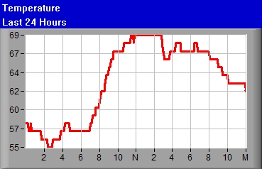
Temperature 83.0°F (Airport mtr004KEWN°F mtr003KEWN)
|
|
|
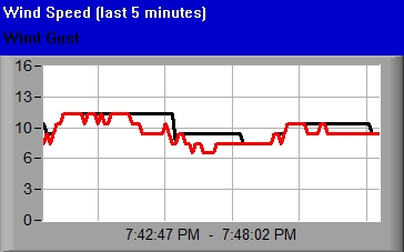
Wind Gust 0mph
|
|
|
Direction SSW
|
|
|
Humidity 0%
|
| Wind Chill 83.0
|
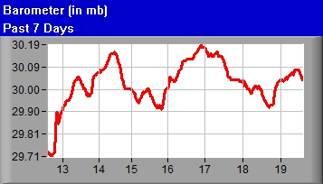
Barometer 1009.19
|