|
Last
Updated 9:20pm on 5/1/24
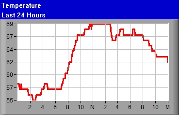
Temperature 70.0°F
(Airport mtr004KEWN°F)
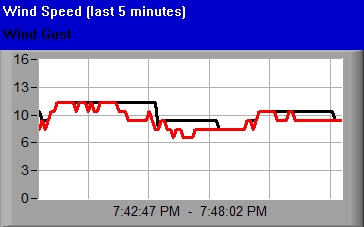
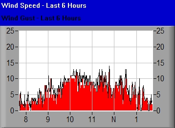
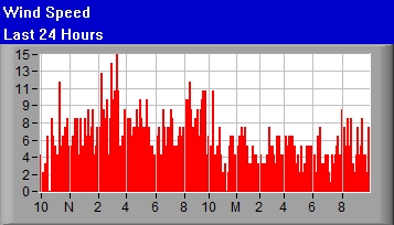
Wind Speed Currently
2Mph SSW
Average over last minute


Light Air
mtr014KEWN
|
Temperature 70.0°F
(Airport mtr004KEWN°F)
|
|
|
|
|
|
|
|
Wind Gust 5mph

|
|
Direction SSW

|
|
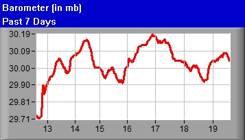
Barometer 29.98
|
|
Wind Chill 70.0 
|
|
|
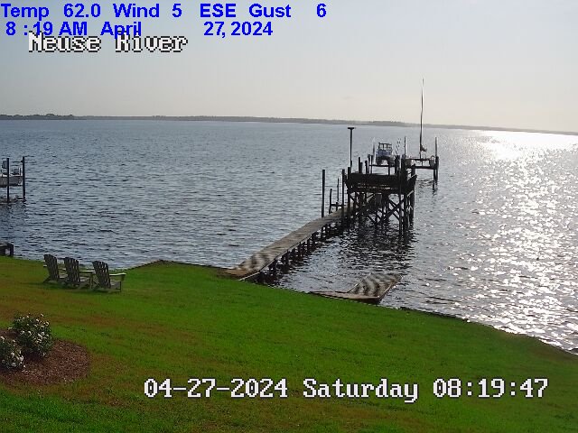
Viewing mouth of Upper Broad Creek, just below Northwest Creek and
Fairfield Harbour, taken South of Johnson Point facing ENE

Viewing Minnesott - Cherry Branch in distance, taken South of Johnson Point facing
South
East
Refresh
New Bern Area Weather Forecast
Weather Synopsis
.Synopsis for Eastern North Carolina coastal waters...
High pressure then builds in for a couple of days before yet
another cold front impacts the area over the weekend.

$$
|
Neuse and Bay River Marine Forecast
Neuse and Bay Rivers-
657 PM EDT Wed May 1 2024

.TONIGHT...S winds 5 to 10 kt, becoming SW after midnight. Waves
flat. Isolated showers and tstms early this evening. Patchy fog
late.
.THU...W winds around 5 kt, becoming E in the afternoon. Waves
flat, increasing to light chop in the afternoon. Patchy fog in
the morning with vsby 1 to 3 NM.
.THU NIGHT...S winds 5 to 10 kt. Waves light chop.
.FRI...SW winds 5 to 10 kt, becoming S in the afternoon. Waves
light chop.
.FRI NIGHT...S winds 5 to 10 kt. Waves light chop.
.SAT...SE winds 5 to 10 kt. Waves light chop.
.SAT NIGHT...SE winds around 10 kt. Waves light chop.
.SUN...S winds around 10 kt. Waves light chop. A chance of
showers.
.SUN NIGHT...S winds around 10 kt. Waves light chop. A chance of
showers in the evening.
.MON...SW winds around 10 kt. Waves light chop. A chance of
showers.
.MON NIGHT...SW winds around 10 kt. Waves light chop.

Winds and waves higher in and near tstms.

$$
|
Pamlico Sound Marine Forecast
Pamlico Sound-
657 PM EDT Wed May 1 2024

.TONIGHT...SW winds 5 to 10 kt, diminishing to around 5 kt late.
Waves 1 ft or less. Isolated showers and tstms early this
evening. Patchy fog late with vsby 1 to 3 NM.
.THU...SW winds around 5 kt, becoming SE in the afternoon. Waves
1 ft or less. Patchy fog in the morning with vsby 1 to 3 NM.
.THU NIGHT...S winds 5 to 10 kt, becoming SW after midnight.
Waves 1 ft or less.
.FRI...SW winds 5 to 10 kt, becoming S in the afternoon. Waves
1 ft or less.
.FRI NIGHT...SE winds 5 to 10 kt. Waves 1 ft or less.
.SAT...E winds 5 to 10 kt. Waves 1 ft or less.
.SAT NIGHT...SE winds around 10 kt. Waves 1 ft or less.
.SUN...S winds around 10 kt. Waves 1 ft or less. A chance of
showers.
.SUN NIGHT...S winds around 10 kt. Waves 1 ft or less. A chance
of showers.
.MON...SW winds around 10 kt. Waves 1 ft or less. A chance of
showers.
.MON NIGHT...SW winds 10 to 15 kt. Waves 1 ft or less, then
around 2 ft after midnight.

Winds and waves higher in and near tstms.

$$
|

https://www.neuseweather.com/windspeed.jpg


